Mt Kumgang Hiking
Mt Kumgang Hiking
Introduction
Location
Visiting
Cost
Tips
Further Information
Introduction
Mt. Kumgang, known in Korean as Kumgangsan, is one of Korea’s famed mountains and the one which many consider to be the most beautiful.
How beautiful is it? Well, Kumgang means ‘diamond’ in Korean thus making it Korea’s diamond mountain.
It is one of the most scenic places in all of Korea that truly lives up to its name and has been immortalised in countless Korean artworks, songs, and even has Taekwondo movies and cosmetics named after it. Chances are that the mountains in the paintings and pictures at your hotel in Pyongyang are of Mt Kumgang! It has even been recognised by UNESCO as a biosphere reserve.
It’s not a single peak though, rather it is a large mountain range featuring snowy peaks right through to seaside cliffs and with many stunning sceneries in between. The area has been divided into three areas based with there being Inner Kumgang (naekumgang), Outer Kumgang (oekumgang) and Sea Kumgang (haekumgang).
Location
Mt Kumgang is located in the Southeast corner of North Korea on Korea’s beautiful east coast, just a short distance from the DMZ border with South Korea (which for the record can’t be visited in the north here).
It takes a full day of driving to get here from Pyongyang, but as you have to go via Wonsan you will generally have your trip to get here broken up into smaller bite-sized holiday adventures.
If looking to add this to a private tour you will need at least three days/two nights in your itinerary to accommodate it.
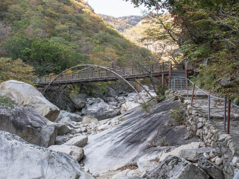
There are six hiking courses at Mt Kumgang, with the most popular being the hike to Kuryong (nine dragons) Waterfall. You’ll be driven to the start of the hike by your local Korean driver which for the Kuryong Waterfall course is about 10 minutes away from the Kumgangsan Hotel.
Visiting
Hiking Kumgangsan is really great and well worth the trip if you have time on your tour. It is certainly one of the best in Korea!
Each season gives Mt Kumgang a unique character and it really is beautiful all year round, though winter makes it very difficult to do much hiking with the snow, ice and general cold.
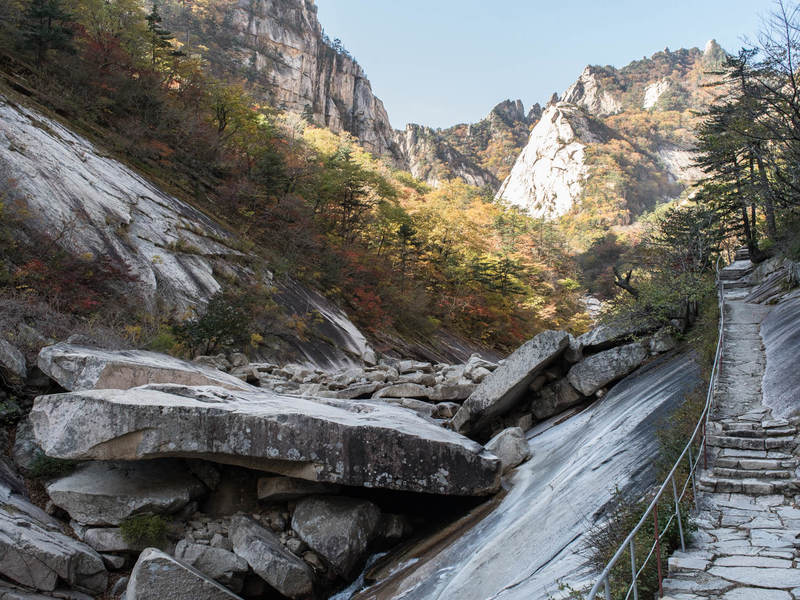
The hiking courses here are excellent as they are really well set out and well equipped. While each trail has its own difficulty level, there is something for just about all skill and fitness levels.
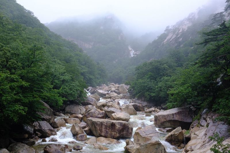
The Kuryong Waterfall course is the most popular hike in the area as most can comfortably conquer it as it is mostly a quite flat course that follows the river up the valley to the waterfall. It takes about two hours from the car park to the waterfall (that is a 4-hour round trip), though many are able to complete it in less time. If time allows then you can extend your hike with the Sangpaldam course.
The Kuryong course has several highlights along the way including;
- Samroksu Spring – a natural water spring believed to contain both ginseng and deer antlers, they say drinking it on the way up makes you 10 years younger and drinking it on the way down will take another 10 years off!
- Kumgangmun – a natural stone gate, one of the five found in the Kumgangsan Range
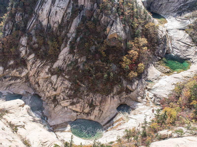
- Okryu Dam & Waterfall – a series of ponds & waterfalls filled with water the colour of a most beautiful green
- Ryonjudam Ponds – two ponds located at the bottom of Bibong Waterfall, they say two angels came down to play and dropped jewels that created the ponds
- Bibong Waterfall – one of four famous waterfalls of Kumgangsan, where the water cascades down the cliff it looks like a phoenix with its wings open.
- Sangpaldam – can only be seen from the top of Goryongdae Observatory, it is a series of eight ponds.
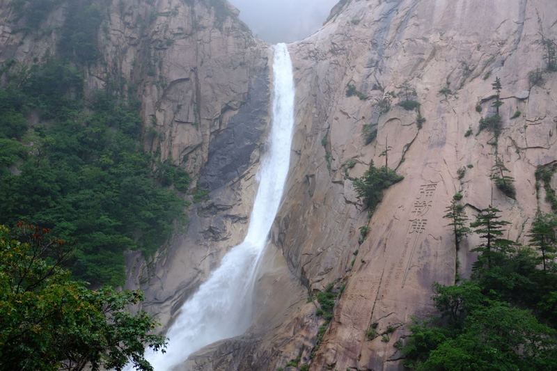
- Kuryong Falls – one of Korea’s three famous waterfalls (along with Pakyon Falls near Kaesong and Daesung Falls in the Seoraksan National Park near Sokcho), it is 74 metres tall, and over time has carved out a pool 13 metre deep at its base. Its name means ‘nine dragons’ as according to local legend nine dragons once lived here that protected the Kumgangsan mountains.
-
The ares is famous for the folk-tales of the Kumgang Fairies. You will find the imagery of these flute playing women throughout the country.
The falls have a pavilion which is the end of the course, and from where you can rest and enjoy the scenic view before returning.
There is a junction before reaching Kuryong Waterfall which is for the Sangpaldam trail course. This course is short but very steep and typically takes around 30-45 minutes to get to the top. It is a difficult course which is mostly climbing up steep stairs.
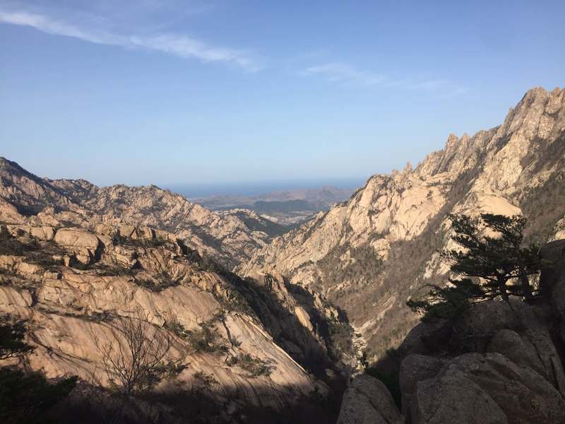
Sangpaldam course climbs up Goryongdae to its observatory which gives you a stunning view of the Mt Kumgang range, the eight ponds that feed water to Kuryong Waterfall and on clear days a view down the valley and out to the East Sea of Korea. It is well worth the effort!
Hikes on Mt Kumgang are usually accompanied by a local guide. They are all Kangwon Province natives and experts on the area, so do ensure to listen to them especially when it comes to safety and the weather.
Cost
There is no cost to visit Mt Kumgang.
Tips
- Do ensure to dress appropriately for hiking including appropriate footwear, and dress for the weather.
- Do also bring a bag to carry items and bring a bottle(s) of water to keep you hydrated.
- Don’t be misled by the hiking trail map – it looks like the Kuryong Waterfall trail is a circuit course, but it is actually attached to another, much longer hiking trail so once you get to Kuryong Waterfall either return the way you came from or if time permits head up the Sangpaldam course (and then come back the same way). If you continue along the path past the waterfall it will be quite a long time before you come out the other end!
- Sometimes the local guides will advise against the Sangpaldam course as the Goryongdae observatory can become shrouded in clouds which would make for a disappointing view after expending the energy to climb it, and it can also make it more treacherous on the climb up and down.
- There is a large toilet block at the car park, and a couple of basic toilets along the trail so do bring your hand sanitiser and/or tissues in case you need to answer the call of nature.
- There is a restaurant at the start of the course called Mokran Restaurant where sometimes you will find the staff here cooking snacks in the outdoor cooking area for returning hikers - having some small change on you is handy as you may well be feeling hungry after your hike.
- Lastly, and most importantly - pay attention to the pre-hike briefing given by your guide team.
Further Information
- Mt Kumgang actually has seasonal names - in spring it is Mt Kumgang, in summer it is Mt Bonglae, in autumn it’s Mt Pungak and in winter Mt Gaegol. To further add to the difficulty of remembering its names when it is covered in snow its name then becomes Mt Seolbong.
- The Mt Kumgang tourist area was developed by the South Koreans from the late 1990s through to the 2000s when a tourist program for South Koreans operated here which greatly benefitted the area by improving access and the experience of visiting here.
- The highest peak of the Kumgangsan mountain range is Birobong which reaches 1,638 metres above sea level.
- The Mt Kumgang mountain range is actually one part of a much larger range of mountains called the Taebaek Mountains that stretch along Korea’s east coast from Mt. Hwangnyong just south of Wonsan in North Korea through to the southern end of the peninsula finishing at the South Korean city of Busan. For this reason, the Taebaek Mountains are also referred to as the ‘spine’ of Korea.
- On the road to Mt. Kumgang from Wonsan you will get a good view of the island of Ryodo – during the Korean War it was the location of a UN military base which was developed into an airbase called Briscoe Field, and then in 1968 was the closest point the USS Pueblo got to North Korea when it was seized.
Interested in a tour to North Korea?
Travel to North Korea with the only
North Korea travel experts, Koryo Tours
North Korea Travel Guide PDF | Sign up to the mailing list | About Koryo Tours
Share